

Peebles Weather - Flight Tracking (Local)
Daytime temperatures are in direct sunlight so may be higher than official air temperature values.
As with any other website, we log your IP address and browser type in the server logs for diagnostic reasons. Cookies are used to record visit time and gauges preferences. No personal information is stored or processed.
All times are in local time (GMT, or BST in summer) unless specified.
2026/07/23 21:50 EGPH 232150Z 27008KT 9999 FEW028 14/10 Q1021
| 13.6°C | 0.0 mm | 0.0 mm | 0.0 mm | 2.5 mph | 4.5 mph | 1020.9 hPa | 83% |   |
 |
|||||||||||
| Station | Warn | Rain | Snow | Flood | Wind | Ltng | Heat | Cold | Glob | Moon | Temp | Rain 1h | Rain Thu | Rain 24h | Wind | 10m Gust | Pressure | Hum |  |
|
| m | Waxing Gibbous | Cool | F1-W | F:- A:- Kp:- SSN:- |
Warning: Undefined array key 3 in C:\xampp\htdocs\wx\meteo.php on line 194
Warning: Undefined array key 0 in C:\xampp\htdocs\wx\meteo.php on line 204
Warning: Undefined array key 1 in C:\xampp\htdocs\wx\meteo.php on line 209
Warning: Undefined variable $htxt in C:\xampp\htdocs\wx\statheader.php on line 105
Flight Tracking
VirtualRadar
Currently running a RTL2832-based DVB-T (Digital TV) USB dongle (with R820T tuner) through software called RTL1090 to decode the ADS-B Mode-S packets that aircraft transmit on 1090MHz when interrogated by air traffic control radar.
I'm running PlanePlotter locally to share data with other PlanePlotter users, and VirtualRadar Server to generate the map shown below. FR24 is being used to share my data with FlightRadar24.com website (shown on that site as T-EGPH4).
This is running on a basic home-made vertical dipole antenna at my bedroom window for now.
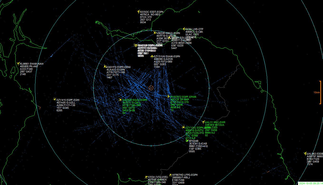
The location of the aircraft on the map are shown by an X. The length of the stalk denotes the altitude with the aircraft at the top.
Note that not all aircraft transmit their location all the time so there will be more in the list than shown on the map.
Formatted Raw Data from RTL1090
Data refreshes every 3 seconds.
Screengrab from PlanePlotter Output
Blue dots are previous confirmed positions of aircraft detected (where they transmit coordinates). This gets cleared every time I move or refresh the map but gives an idea of frequently used flight paths and hold patterns. I have added shared aircraft from other PlanePlotter users. Ones with green text are detected by me, grey text are the shared ones.
 XHTML 1.1 | CSS
Warning: Undefined array key "debug" in C:\xampp\htdocs\wx\sitefooter.php on line 44